KOSI FLOODS & THE EMBANKMENT PARADOX
Context
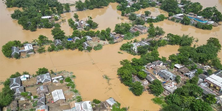
- The Kosi River breached its embankment again in 2024, repeating past disasters such as the 2008 Kusaha breach that affected 33 lakh people.
- This raises fresh questions about whether concrete embankments actually protect flood-prone plains, or whether they worsen long-term vulnerability.
- Experts, local communities, and geologists are increasingly arguing for alternatives to embankment-based flood control.
What are Embankments?
- Artificial walls made of earth, stone, or concrete built along rivers to “contain” water.
- Intended to prevent flooding, protect agriculture, and enable settlements.
ABOUT RIVER KOSI
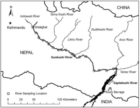
• Origin & Course
- Originates in Tibet (China), flows through Nepal, and enters India in Bihar.
- Known as Sapta Kosi (formed by 7 Himalayan tributaries – Sun Kosi, Arun, Tamur, dudh kosi, Indravati, Likhu, and Tamur).
- Joins the Ganga near Kursela, Bihar.
• Geographical Characteristics
- A high-sediment, braided Himalayan river.
- One of the most dynamic rivers in the world.
- Has shifted ~120 km westwards in the last 250 years due to natural sedimentation.
- Known as the “River of Sorrow” because of recurrent destructive floods.
• Hydrology & Sedimentation
- Carries one of the highest sediment loads among Himalayan rivers.
- Natural tendency to avulse (sudden course shift).
• Flood Issues
- Major breaches of embankment: 1963, 1968, 1971, 1980, 1984, 1987, 1991, 2008, 2024.
- 2008 Kusaha breach:
- Affected 33 lakh people, over 400 deaths.
- Considered one of India’s worst flood disasters.
• Socio-economic Importance
- Supports agriculture in north Bihar’s plains.
- Floods bring temporary soil fertility but long-term devastation.
- Millions live in diara lands (between river and embankments).
- High migration from Kosi belt due to chronic flood risk.
• Western vs Eastern Himalayan Rivers
- Kosi is an affluent river (precipitation increases downstream).
- Eastern Himalayan rivers = high rainfall + weak geology → embankments less stable.
- Western Himalayan rivers = more stable, embankments sometimes workable.
• Climate Change Angle
- Intensified monsoon bursts → higher sediment load → more unpredictable floods.
- Increased glacial melt may alter flow patterns.
WHY DO EMBANKMENTS FAIL?
• Historic Warnings
• 1951 G.R. Garg Committee warned embankments disrupt natural river functions:
• Land creation (erosion & deposition)
• Basin drainage
• People’s Commission reports highlight ecological distortions caused by embanking Kosi.
• Experts argue for “living with floods” strategy instead of hard engineering.
• Science of the Problem
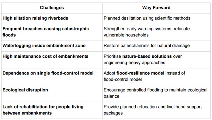
• High Silt Load
• Himalayan rivers carry enormous sediment.
• Embankments trap the river between two fixed walls that leads to silt accumulation, because of which riverbed rises each year.
• Height Race
• To prevent overtopping, governments keep raising embankments → unsustainable costs.
• When Breach Happens
• Breach is the sudden release of water from an elevated channel, leading to catastrophic floods that are much worse than natural floods.
• Waterlogging & Flooding Inside Embanked Zone
• Communities living between embankments and river (the “diara lands”) get trapped and waterlogged.
Evidence of Repeated Failures
• Kosi breached embankments multiple times: 1963, 1968, 1971, 1980, 1984, 1987, 1991, 2008, 2024
• Similar patterns are seen in Brahmaputra (Assam), Gandak, Bagmati.
INFLUENT V/S EFFLUENT RIVERS
- Western Himalayan rivers → influent (precipitation decreases downstream): Embankments may work better.
- Eastern Himalayan rivers (Kosi, Brahmaputra, etc.) → effluent (precipitation increases downstream): Embankments are geologically risky.
Paleochannels
- Ancient abandoned river channels that naturally hold excess water.
- Reviving them improves natural drainage.
WHY FLOODS WITHOUT EMBANKMENTS ARE MILDER?
- Without embankments, rivers spread gently over floodplains.
- Silt distributes naturally → fertility improves.
- Water levels drop faster.
- Damage is widespread but not violent.
US Example
- US Army Corps of Engineers removed embankments in several basins.
- Result: reduced catastrophic floods and restored wetlands.
THE POLITICS OF EMBANKMENTS
- In Bihar elections, political promises emphasise “flood-to-fortune” river-linking (Kosi–Mechi project).
- However, 5,247 cusecs diverted is negligible compared to Kosi’s 6 lakh cusecs during flood, proving river-linking will not reduce flood intensity.
IMPLICATIONS
- Greater Flood Vulnerability due to siltation and breaches.
- Permanent Waterlogging for communities trapped between embankments.
- Ecological Degradation – groundwater imbalance, loss of wetlands.
- High Fiscal Cost – raising and repairing embankments every few years.
- Social Injustice – most affected are poor farmers, with little rehabilitation.
- Policy Blind Spots – engineering solutions overshadow traditional ecological knowledge.
Note: Connect with Vajirao & Reddy Institute to keep yourself updated with latest UPSC Current Affairs in English.
Note: We upload Current Affairs Except Sunday.