
SIR CREEK DISPUTE
Why is Sir Creek in the News Again?
- Recently, in October 2025, the dispute resurfaced due to military build-up by Pakistan in the Sir Creek area.
- In response, India’s Defence Minister Rajnath Singh issued a strong warning, stating that any “misadventure” in the region could “change both history and geography.”
- This statement reflects just how critical this area is to India’s national interest.
- These comments came during a military event in Bhuj, Gujarat, and were a direct warning to Pakistan, which has recently expanded its military activities near Sir Creek — including building new bunkers, radars, and military posts.
- But why is this small stretch of marshy land and water so important? And why have India and Pakistan failed to settle this border issue for decades?
WHAT IS SIR CREEK?
Sir Creek is a 96-kilometre-long tidal water channel located between India’s Gujarat (Rann of Kutch) and Pakistan’s Sindh province.
- It’s called a “tidal estuary”, which means the flow of water changes with the tide.
- It was earlier known as Ban Ganga, and the British later renamed it Sir Creek.
- The area around it is marshy, flood-prone, and full of snakes, scorpions, and muddy terrain — making it very difficult to live in or even patrol.
Even though the land is difficult to use, Sir Creek is very important for security, economy, and boundary rights. That’s why both countries want control over it.
HISTORY OF THE DISPUTE
The Dispute Goes Back to the British Era
- The conflict over Sir Creek started more than 100 years ago during British rule in India. At that time, the rulers of Kutch (now part of India) and the Sindh government (now part of Pakistan) argued over who had the right to collect firewood near the creek.
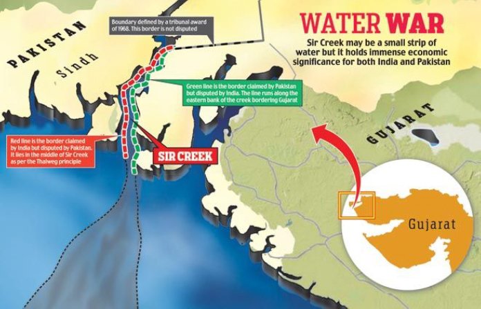
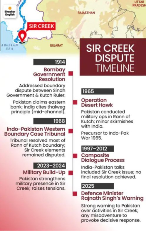
- In 1914, the Bombay Presidency (the British administrative authority in that region) tried to settle the dispute by issuing a resolution to define the boundary.
- However, this resolution had two conflicting statements:
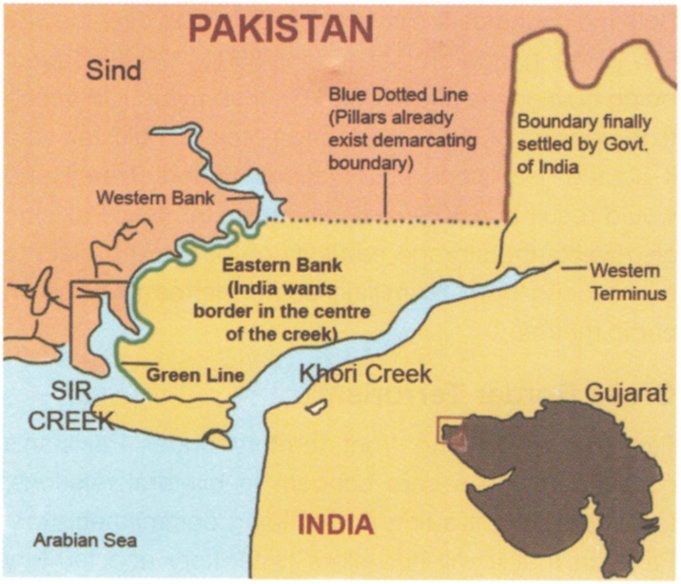
- Paragraph 9 said the boundary was the eastern bank of the creek, which means the entire creek would belong to Sindh (now Pakistan).
- Paragraph 10 applied the Thalweg Principle, which says that in rivers or creeks, the boundary should be drawn along the middle of the deepest channel. This meant the creek should be shared, supporting India’s claim.
- So, from the beginning, the document itself was unclear, and both countries used different parts of it to support their positions.
WHAT HAPPENED AFTER 1947?
After Independence, Kutch became part of India, and Sindh became part of Pakistan. This made Sir Creek an international boundary issue.
- In 1965, Pakistan even claimed more than half of the Rann of Kutch. A war broke out between the two.
- In 1968, a tribunal set up by the UN gave 90% of the Rann of Kutch to India, but left out Sir Creek because it was too complex due to its shifting nature and water-based geography.
Since then, the Sir Creek dispute has remained unresolved.
KEY EVENTS
- 1989: First formal talks in Islamabad. No results.
- 1990–1992: More rounds of talks in Rawalpindi and New Delhi. Still no solution.
- 1998: A Sir Creek Working Group was formed. India opposed Pakistan’s move to take the issue to international courts, saying it must be solved bilaterally, as per the Simla Agreement (1972).
- 2005–2007: Joint surveys were done by both countries to map the creek, but the data was never used to reach a deal.
- 2012: Last formal round of talks took place.
- 2016: After the Pathankot terror attack, India stopped all structured dialogue, including on Sir Creek.
WHAT DO INDIA & PAKISTAN CLAIM?
| Country | Claim |
| Pakistan | Says the entire creek belongs to Pakistan, as per Paragraph 9 of the 1914 agreement (eastern bank as boundary). |
| India | Says the creek is navigable during high tide, so the Thalweg Principle applies. The boundary should be in the middle of the creek. India also shows proof like the 1925 map and mid-channel pillars from 1924. |
- Pakistan argues the creek is not fully navigable, so Thalweg should not apply. India says it is navigable, especially during high tide, and fishermen use it regularly.
- This legal difference over one principle — Thalweg — has kept the issue stuck for years.
STRATEGIC IMPORTANCE OF SIR CREEK
Sir Creek may look unimportant on the map, but it is crucial for national security, especially for India. Here’s why:
1. Close to Karachi – Pakistan’s Economic Lifeline
- Karachi, the largest city and main port of Pakistan, is just south of Sir Creek.
- Any Indian movement in Sir Creek is seen as a direct threat to Karachi.
- That’s why Pakistan has built bunkers, radars, and military posts near the area recently.
2. Gateway for Terror Infiltration
- In the 2008 Mumbai attacks, terrorists came by sea from Karachi, entered Indian waters through Sir Creek, and hijacked an Indian boat.
- Since then, India has tightened coastal security in the area.
- Still, the creek remains hard to monitor, and could again be used for smuggling, infiltration, or terror attacks.
3. Chinese Interest
- There are concerns that China, through its support of Pakistan and the China-Pakistan Economic Corridor (CPEC), may try to increase its presence near the region.
- India sees this as an added security risk.
ECONOMIC IMPORTANCE
1. Oil and Natural Gas
- The region is believed to have untapped oil and gas reserves.
- For a country like India, which wants to reduce dependence on imported oil, gaining access to this area is very important.
2. Fishing Industry
- The creek supports rich fishing grounds used by fishermen from both India and Pakistan.
- Due to no clear boundary, hundreds of fishermen get arrested every year for accidentally crossing the border.
- Many spend years in jail, even though they did not intend to cross over. This creates human suffering and worsens public opinion on both sides.
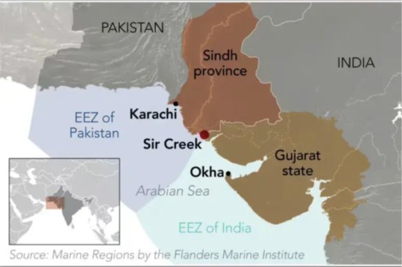
3. Exclusive Economic Zone (EEZ)
Under international law (UNCLOS), a country has rights over sea resources in a zone called the Exclusive Economic Zone, which extends 200 nautical miles from the coast.
- If the Sir Creek boundary shifts even by a few kilometres, it could change the EEZ by thousands of square kilometres.
- That means more sea area, more oil and fish, and more strategic control — making this dispute economically and politically important.
EFFORTS TO RESOLVE THE DISPUTE
- India and Pakistan have held several rounds of talks over the years, but no final agreement has been reached.
- In 1968, an international tribunal, urged by UK Prime Minister Harold Wilson after the 1965 war, resolved most border issues in the Rann of Kutch but left Sir Creek unresolved citing its technical complexity due to the tidal and shifting nature of the estuary. The tribunal gave Pakistan about 10% of the disputed territory.
- In the 1972 Simla Agreement, both countries agreed to resolve bilateral disputes through peaceful dialogue. India has since insisted on resolving Sir Creek bilaterally, whereas Pakistan has pushed for international arbitration, which India opposes.
WHY HAS DISPUTE NOT BEEN RESOLVED YET?
There are several reasons why the Sir Creek dispute remains unresolved:
- Legal Ambiguity: The 1914 resolution is contradictory, and both sides have historical documents to support their positions.
- Shifting Geography: Being a tidal estuary, Sir Creek’s course changes with time, making it difficult to set a permanent boundary.
- Lack of Political Will: Larger bilateral issues like Kashmir and cross-border terrorism often take precedence, leaving Sir Creek on the back burner.
- Mutual Distrust: Given past betrayals, especially Pakistan’s support for terror groups, India cannot afford to trust Pakistan’s intentions in the region.
However, ignoring the dispute is not an option. An undefined boundary in such a sensitive location poses a constant security risk, and it hampers India’s ability to fully utilise its maritime resources.
CONCLUSION
Sir Creek is a small but highly strategic area critical to India’s national security, economic interests, and maritime rights. The unresolved boundary affects security, energy resources, and livelihoods of thousands. Until both countries agree on the boundary, Sir Creek will continue to be a major point of tension. For India, maintaining a strong military presence and pursuing diplomatic dialogue on its own terms remains vital. A peaceful, bilateral resolution would help improve regional security and allow both countries to benefit from the area’s resources.
Note: Connect with Vajirao & Reddy Institute to keep yourself updated with latest UPSC Current Affairs in English.
Note: We upload Current Affairs Except Sunday.