

MAHARASHTRA EARTHQUAKE SWARM
Why in News?
- Maharashtra has experienced a series of small earthquakes over the last fortnight.
- Around 29 tremors were reported:
- 24 in and around Nashik
- 4 in Palghar
- 1 in Nagpur
- The strongest tremor was recorded in Nagpur on 8 August, with a magnitude of 4.3.
- Most of the earthquakes were shallow, occurring at depths of around 5–8 km.
- Since there was no clear mainshock and several earthquakes of comparable magnitude occurred over a period of time, seismologists describe this pattern as an earthquake swarm.
WHAT IS AN EARTHQUAKE?
- An earthquake is the sudden movement of rocks along a fault or zone of weakness in the Earth’s crust.
- Rocks can remain locked because of friction even when forces are acting on them.
- As stress continues to build, the rocks may eventually slip and release stored energy as seismic waves.
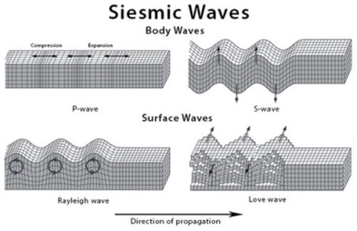
MAJOR TYPES OF SEISMIC WAVES
- P Waves: Compress and stretch rocks in the direction in which the waves travel.
- S Waves: Move rocks sideways through a shearing motion.
- Surface Waves: Travel along the Earth’s surface.
- The combined movement of these waves produces the shaking experienced at the surface.
WHAT IS AN EARTHQUAKE SWARM?
- In a normal earthquake sequence, a major mainshock is usually followed by smaller aftershocks.
- In an earthquake swarm, there is no clearly identifiable mainshock.
- Instead, several earthquakes of relatively comparable magnitude occur over days or even longer periods.
- Their magnitudes can fluctuate during the swarm.
Important Point
- An earthquake swarm does not necessarily mean that a larger earthquake is about to occur.
- Different earthquake swarms can have different causes.
Examples
- Palghar, Maharashtra: Experienced a major earthquake swarm beginning in November 2018, with thousands of earthquakes continuing for more than a year.
- More short-duration seismic activity has also been recorded in the region in subsequent years.
- Campi Flegrei, Italy: A major seismic swarm occurred in mid-2024. On 20 May, more than 150 earthquakes were recorded within a few hours, including a magnitude 4.4 earthquake, the strongest in the region in four decades.
WHY DOES MAHARASHTRA EXPERIENCE EARTHQUAKE SWARMS?
1. Intraplate Location
- Maharashtra lies far from a major tectonic plate boundary.
- Therefore, many earthquakes occurring in the State are classified as intraplate earthquakes.
- Such earthquakes occur within a tectonic plate, rather than at its boundary.
2. Deccan Traps
- Much of Maharashtra lies on the Deccan Plateau.
- Its bedrock mainly consists of extensive basaltic lava flows, known as the Deccan Traps.
- These formations were created around 66 million years ago when huge quantities of lava erupted through fissures in western-central India.
- Thousands of individual lava flows accumulated over time, in some places reaching hundreds of metres in thickness.
- After solidification, these basalt layers developed fractures and other weaknesses.
- Such structures can transmit accumulated tectonic stress in ways similar to faults.
3. Continuing Movement of the Indian Plate
- The Indian Plate continues to move and deform.
- This movement generates and accumulates stresses even in the interior of the plate.
- Since the Deccan Plateau lies within the Indian Plate, these stresses can activate existing fractures and structures.
4. Local Geological Structures
- Studies around Nashik have identified geological structures such as:
- Shear zones
- Fractures
- These structures can contribute to local seismic activity.
WHAT ROLE DOES WATER PLAY IN EARTHQUAKE?
Rainfall-Triggered Seismicity
- Water can move deeper underground through:
- Soil
- Fractures
- Permeable rocks
- If water reaches a network of cracks connected to a fault, it can increase pore pressure.
- Increased pore pressure can reduce the stability of rocks and contribute to fault movement.
- When rainfall-induced water movement triggers earthquakes, the phenomenon is called rainfall-triggered seismicity.
EVIDENCE FROM PALGHAR
- Researchers studying the 2018 Palghar earthquake swarm using satellite data found evidence of land subsidence.
- They suggested that rainwater entering the subsurface could have helped trigger faults.
- A detailed study of more than 21,000 earthquakes recorded between January 2019 and October 2020 found that seismic activity increased following rainfall.
- The study suggested that water migrated through cracks and fissures, increasing pore pressure and helping drive the earthquake swarm.
BUT RAINFALL IS NOT THE ONLY EXPLANATION
- Other studies have given different views about the importance of rainfall.
- Possible contributing factors include:
- Normal faulting
- Aseismic deformation
- Tectonic stresses
- Existing geological structures and fractures
Aseismic deformation refers to gradual movement or deformation of the Earth’s crust that does not produce a detectable earthquake
Koyna: Reservoir-Triggered Seismicity
- Maharashtra’s Koyna-Warna reservoir region is a famous example of reservoir-triggered seismicity.
- Scientists have observed earthquakes in the region for decades.
1967 Koyna Earthquake
- On 10 December 1967, a magnitude 6.3 earthquake occurred southwest of the Koyna Dam.
- It caused extensive damage in Koynanagar.
- Houses were destroyed and more than 200 people were killed.
- Such a major earthquake was unprecedented in the region.
Link with the Reservoir
- There was reportedly no recorded seismicity in the region before construction of the dam began in 1956.
- The Koyna reservoir was filled in 1962.
- Seismic activity began after the reservoir was filled and could be detected at the seismological station in Pune, around 120 km away.
- Minor seismic activity eventually culminated in the 1967 Koyna earthquake.
Note: Connect with Vajirao & Reddy Institute to keep yourself updated with latest UPSC Current Affairs in English.
Note: We upload Current Affairs Except Sunday.