MYTHS OVER CHINA’S CONTROL OVER BRAHMAPUTRA RIVER
Context:
- Following India’s decision to suspend the Indus Waters Treaty with Pakistan, discussions about water sharing in South Asia have become more intense.
- This has brought attention to the Brahmaputra River, with India firmly stating its control over its water resources and rejecting claims that China significantly controls the river’s flow.
- There is a common myth, often spread by Pakistan, that China’s actions on the Brahmaputra could threaten India’s water security.
- However, this claim is based on incorrect information about the river’s geography and water sources.
DEBUNKING THE MYTH OF CHINA’S CONTROL
- The Misconception:
- A common myth, often fueled by Pakistan, suggests that China’s actions on the Brahmaputra could threaten India’s water security.
- Pakistan, having historically benefited disproportionately from the Indus Waters Treaty, is now trying to create a false narrative of dependency regarding the Brahmaputra as India reasserts control over its water resources.
- Reality of Brahmaputra’s Flow:
- The Brahmaputra is primarily a rain-fed river system.
- Only approximately 30-35% of its flow comes from China, mostly from Chemayungdung Glacier melt and scanty rainfall in the Tibetan region.
- This constitutes the base flow.
- The majority of the river’s water (about 65-70%) originates within India itself, mainly from monsoon rains over the Northeast’s hilly areas and numerous tributaries.
- India’s Water Independence (Flow Rates):
- At the Indo-China border (near Tuting, Arunachal Pradesh), the flow rate is around 2,000-3,000 cubic meters per second.
- During the monsoon season, as the river enters Assam’s plains, the flow dramatically increases to 15,000-20,000 cubic meters per second.
- These figures clearly show that the river’s volume is overwhelmingly sustained within India’s climatic and geographical boundaries.
- India, thus, does not depend on upstream water flow from China to sustain its water needs.
- Impact of Hypothetical Chinese Water Reduction:
- Minimal Impact on India:
- Even in a hypothetical scenario where China reduces its water contribution (which is unlikely as China has never officially threatened such an action), the impact on India’s water security would be minimal.
- Potential Benefit for Floods:
- A reduced flow from upstream China could actually help mitigate the severe annual floods that devastate Assam and the northeastern region, displacing hundreds of thousands and destroying livelihoods.
- This indicates India’s water system is resilient and mainly driven by monsoons and local tributaries.
- Minimal Impact on India:
- Current Realities and Policy Implications:
- Ironically, while fears about China’s water control persist, the region is currently facing an acute flood crisis driven by heavy monsoon rains.
- India’s flood mitigation strategies should align with this reality, focusing on improving infrastructure and enhancing resilience against floods, rather than worrying about largely hypothetical threats.
- Assam’s Chief Minister Himanta Biswa Sarma has asserted that the Brahmaputra is mainly shaped by India’s geography, monsoon rains, and the resilience of its people.
- Discussions about water sharing and politics in the region should be based on facts and reason, not on myths or politics.
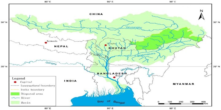
ABOUT THE BRAHMAPUTRA

- Names:
- Yarlung Tsangpo in Tibet.
- Siang or Dihang in Arunachal Pradesh, India.
- Brahmaputra in Assam, India.
- Jamuna in Bangladesh.
- Also generally referred to as Tsangpo-Brahmaputra.
- Length: 6th-longest river in Asia, approximately 2,900 km.
- Origin: Originates in the Tibetan Plateau (specifically, Chemayungdung mountain ranges at 5,150 meters, near Konggyu Tsho lake). The Chemayungdung Glacier is its primary source.
- Flow: Flows eastward through the Tibetan Plateau, enters India, then Bangladesh, and finally empties into the Bay of Bengal.
THE BRAHMAPUTRA RIVER BASIN
- Total Area: Spreads across Tibet, Bhutan, India, and Bangladesh, covering a total area of 5,80,000 square kilometers. It is one of the largest river basins in Asia.
- In India: The Brahmaputra basin covers 1,94,413 square kilometers, which is about 9% of India’s total geographical area.
- States Covered: Arunachal Pradesh (81,424 sq km), Assam (70,634 sq km), West Bengal (12,585 sq km), Meghalaya (11,667 sq km), Nagaland (10,803 sq km), and Sikkim (7,300 sq km).
COURSE OF THE RIVER
- Tibet (Yarlung Tsangpo):
- Flows eastward for about 1600 km through the Tibetan Plateau, parallel to the Himalayas.
- India (Siang/Dihang to Brahmaputra):
- Enters India in Arunachal Pradesh as the Siang or Dihang river.
- Takes an S-shaped bend near Bishing village at the Indian border.
- Further downstream, it is joined by the Lohit and Dibang rivers to form the mighty Brahmaputra river.
- Flows in a south-easterly direction for about 230 km through Arunachal Pradesh before entering the Assam valley.
- Travels a total distance of 916 km within India (through Arunachal Pradesh and Assam).
- Bangladesh (Jamuna to Meghna):
- After entering Bangladesh, it is known as the Jamuna river.
- The Jamuna is joined by the Ganga River (known as the Padma river in Bangladesh).
- Eventually, the Brahmaputra (as Jamuna-Padma) joins the Meghna River and finally empties its water into the Bay of Bengal.

Note: Connect with Vajirao & Reddy Institute to keep yourself updated with latest UPSC Current Affairs in English.
Note: We upload Current Affairs Except Sunday.